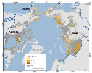
Extending the international outreach of NGEE-Arctic, Bill Riley and Charlie Koven of LBNL worked with Sina Muster of the Helmholtz Centre for Polar and Marine Research and a large team to develop and publish a database of waterbodies in permafrost regions (Muster et al. 2017). This database is critical to the scientific community’s ability to estimate the long-term dynamics of high-latitude waterbodies and the resulting biogeochemical transformations (e.g., CH4 emissions). The Permafrost Region Pond and Lake Database (PeRL) presents a circum-Arctic representation of ponds and lakes from modern (2002-2013) high-resolution aerial and satellite imagery with a resolution of 5 m or better. The data resolve waterbodies with surface areas between 1 and 100 ha from tundra to boreal regions and from continuous to discontinuous permafrost zones. PeRL also includes historical imagery from 1948 to 1965 with a resolution of 6 m or better. In this paper we also present statistics of waterbody distributions for each site. We are currently using these distributions to develop scalable models appropriate for inclusion in land models for large-scale and decadal to centennial prediction. Interestingly, small ponds are the dominant waterbody type by number in all permafrost landscapes and yet are not represented in any Earth System Model.
For more information, please contact:
William Riley
wjriley@lbl.gov

