
Microtopography plays a critical role in regulating the fine-scale variability in thermal and hydrological regimes in the polygonal tundra landscape underlain by continuous permafrost. Jitendra Kumar (ORNL) and others developed an end-to-end effort for high-resolution numerical modeling of thermal hydrology at real–world field sites, utilizing the best available data to characterize and parameterize the models. Their results were published in The Cryosphere. A multiphase subsurface thermal hydrology model (PFLOTRAN) was developed to model the permafrost thermal regimes and applied to study four NGEE-Arctic intensive sites in polygonal tundra at Barrow Environmental Observatory (BEO). Using a high-resolution LiDAR digital elevation model (DEM), micro-topographic features of the landscape were characterized and represented in the high-resolution model mesh. Soil properties observations from the field sites were used to represent the subsurface heterogeneity within the model. Parameterized and forced with site based observations, the model was able to simulate the spatiotemporal patterns of permafrost thermal regimes at the sites. Jitu and his colleagues report that their topography resolving, high-resolution model, was able to simulate the microtopographic-driven spatial patterns in thermal regimes from first principles at four sites representing low-centered to transitional- to high-centered polygonal tundra. Simulation results demonstrate the ability of the developed modeling approach to capture – without recourse to model calibration – several aspects of the complex thermal regimes across the sites, and provide insights into the critical role of polygonal tundra microtopography in regulating the thermal dynamics of the carbon-rich permafrost soils. Areas of significant disagreement between model results and observations highlight the importance of field-based observations of soil thermal and hydraulic properties for modeling-based studies of permafrost thermal dynamics, and provide motivation and guidance for future observations.
Reference:
Kumar, J., Collier, N., Bisht, G., Mills, R.T., Thornton, P.E., Iversen, C.M., and Romanovsky, V. 2016. Modeling the spatio-temporal variability in subsurface thermal regimes across a low-relief polygonal tundra landscape. The Cryosphere Discussion (accepted). http://dx.doi.org/10.5194/tc-2016-29
[[{"fid":"186","view_mode":"default","type":"media","link_text":null,"attributes":{"title":"Figure 1. Temporal pattern and spatial distribution of simulated maximum thaw depth at low-centered polygonal tundra at NGEE Arctic Site A","height":"696","width":"2471","class":"media-element file-default"}}]]
Figure 1. Temporal pattern and spatial distribution of simulated maximum thaw depth at low-centered polygonal tundra at NGEE Arctic Site A
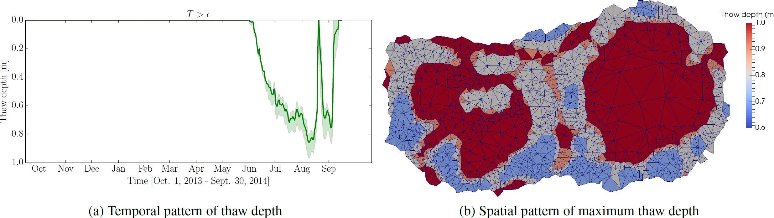
Figure 1. Temporal pattern and spatial distribution of simulated maximum thaw depth at low-centered polygonal tundra at NGEE Arctic Site A
For more information, please contact:
Jitu Kumar
kumarj@ornl.gov