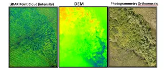
Scientists at LANL surveyed the NGEE Arctic Teller research site (~3km2) in August 2017 with an Unmanned Aerial System (UAS). A state-of-the-art Light detection and Ranging (LiDAR) scanner onboard the UAS acquired centimeter-resolution topography data in the form of a point-cloud (see figure below). In addition to LiDAR, the UAS was equipped with a digital camera that collected high-resolution aerial imagery at 24 Megapixels. Preliminary Lidar and Photogrammetry datasets and derivatives will be presented at the ESS PI meeting. The LiDAR point cloud datasets have a density of 740 pts/m2 and a DEM resolution of 2cm. The LiDAR point-cloud of Teller site will serve as a keystone dataset to better understand the association and co-dependence between topography and multiple environmental processes related to hydrology, geochemistry, geomorphology as well as the relationship between ecosystem structure and function.
For more information, please contact:
Christian Andresen


