
Warmer, dryer conditions and more frequent disturbances are taking their toll on Arctic vegetation
The Arctic tundra biome has become a hot spot of global environmental change because the vegetation and permafrost soils are strongly influenced by warming air temperatures and declining sea ice in the Arctic Ocean. In the late 1990s, global satellite observations revealed a sharp increase in the apparent productivity of tundra vegetation, a phenomenon that has come to be known as Arctic greening. Arctic greening is dynamically linked with Earth’s changing climate, interacting in complex ways with permafrost thaw, snow and sea ice change, and disturbances. However, the greening trend has not been universal, and some areas in the Arctic are even experiencing an opposite browning trend in response to disturbance and extreme weather events.
In NGEE Arctic’s 2022 National Oceanic and Atmospheric Administration Arctic Report Card essay, the team analyzed the most recent evidence for a widespread, but not universal, Arctic greening pattern: long-term satellite records derived from the Advanced Very High-Resolution Radiometer and Moderate Resolution Imaging Spectroradiometer (MODIS). The team showed that the yearly maximum tundra greenness (MaxNDVI) has increased across much of the circumpolar Arctic during 1982–2021 and 2000–2022. However, in 2022, the team observed in MODIS time series data a sharp a decline in greenness in some key areas from the record-high values set in 2020 and 2021. This decline was particularly striking in northeastern Siberia, which experienced unusually persistent summer sea ice and cooler near-surface temperatures. Other areas showed low or reversed greening signals because of record numbers of wildfires or unusually warm and dry conditions.
The team highlighted the need to understand the local and regional variability of vegetation greenness and to parse the drivers of its complex patterns using multiscale remote sensing, especially emerging technologies such as unoccupied aerial systems. These novel platforms are useful for characterizing how fine-scale variation drives larger-scale patterns and for elucidating how extreme weather and disturbances have caused contrasting browning patterns and increased vegetation stress. Combining these novel platforms with traditional satellite monitoring allows for a more complete process understanding of Arctic change and creates a means for addressing the scaling gap betweenfield measurements and satellite-observed patterns of vegetation change.
Using multiscale remote sensing techniques, researchers are uncovering the drivers of complex Arctic greening and browning trends.
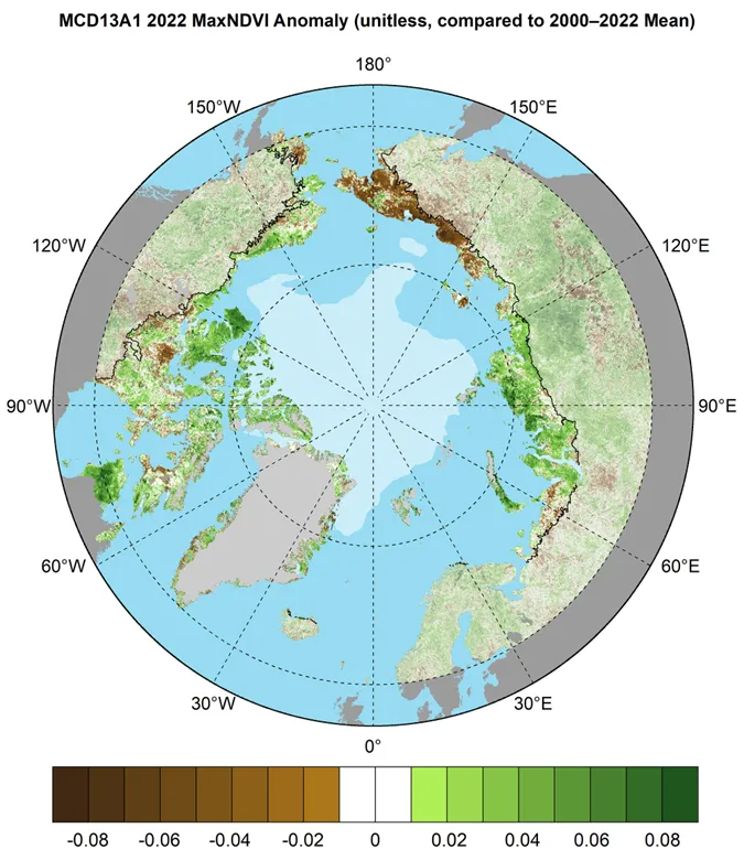
Circumpolar MaxNDVI anomalies for the 2022 growing season relative to mean values (2000–2022) from the MODIS MCD13A1 v6.1 data set. The 2022 minimum sea ice extent is indicated by light shading.
This research was supported by the Director, Office of Science, Office of Biological and Environmental Research of the US Department of Energy under Contract No. DE-AC02-05CH11231 as part of the Next-Generation Ecosystem Experiments (NGEE Arctic) project.
For more information, please contact:
Daryl Yang
yangd@ornl.gov