
PeRL: A Circum-Arctic Permafrost Region Pond and Lake Database
Waterbodies in Arctic permafrost lowlands strongly affect wetland ecosystem processes of carbon, water, and energy fluxes important in regional- to global-scale models. However, there is no robust theory for the distribution or temporal dynamics of these surface features, nor do land models have accurate characterizations. The open source Permafrost Region Pond and Lake (PeRL) database is a critical first step in developing such theories and model representations. Our findings that small waterbodies dominate the number density of all waterbodies, and that their distributions are temporally dynamic, are motivating ongoing work in conceptualizing process representations that can be integrated in land models to improve prediction of high-latitude terrestrial processes.
Ponds and lakes are abundant in Arctic permafrost lowlands and play important roles in Arctic wetland ecosystems by regulating carbon, water, and energy fluxes and providing freshwater habitats. However, waterbodies with surface areas smaller than 104 m2 (ponds) have not been inventoried or characterized in a manner amenable to improving land models. The Permafrost Region Pond and Lake (PeRL) database addresses this problem with a circum-Arctic characterization of ponds and lakes from modern (2002–2013) high-resolution aerial and satellite imagery with a resolution of 5 m or better. We found that ponds are the dominant waterbody type by number in all landscapes.
In addition to characterizing waterbody distributions where detailed information exists, we link results with observations of permafrost extent, ground ice volume, geology, and lithology to extrapolate waterbody statistics to regional landscape units. We also provide historical imagers from 1948 to 1965 with a resolution of 6 m or better. These large-scale waterbody distribution estimates, and their temporal trajectories, will help land modelers improve their representation of surface energy and carbon representations, an exercise we are pursuing for the ACME Land Model.
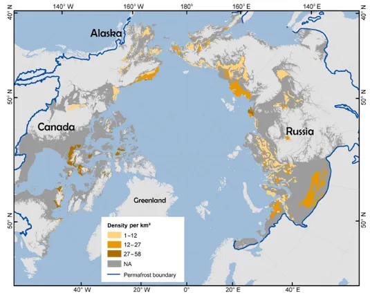
Waterbody density for waterbodies with surface areas of between 102 and 106 m2 within permafrost landscape units. Permafrost boundary was derived from the regional databases.
This research was supported by the Director, Office of Science, Office of Biological and Environmental Research of the US Department of Energy under Contract No. DE-AC02-05CH11231 as part of the Next-Generation Ecosystem Experiments (NGEE Arctic) project.
For more information, please contact:
William Riley
wjriley@lbl.govCharlie Koven
cdkoven@lbl.gov