Microtopography Determines How CO2 and CH4 Exchanges Respond to Temperature and Precipitation in Polygonal Tundra
- Quantified and scaled the effects of microtopography on biogeochemistry, hydrology, and plant processes—and thereby CO2 and CH4 exchanges with the atmosphere—using observations and three-dimensional modeling.
- Polygon microtopography affects CO2 and CH4 emissions, but landscape scaling of polygon types accurately represents landscape exchanges with the atmosphere.
- Much of the spatial and temporal variations in CO2 and CH4 fluxes were driven from topographic effects on water and snow movement.
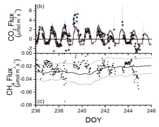
- Demonstrated excellent agreement between modeled and observed CH4 and CO2 fluxes (Figure) and the relevant biogeochemical, hydrological, and thermal controlling processes.
- Results imply needed improvements to the DOE E3SM land model (ELMv1-ECA), which we are pursuing.
Grant, RF, ZA Mekonnen, WJ Riley, HM Wainwright, D Graham, and MS Torn. 2017. Mathematical modelling of arctic polygonal tundra with ecosys: 1. Microtopography determines how active layer depths respond to changes in temperature and precipitation. Journal of Geophysical Research: Biogeosciences, 122:3161– 3173. https://doi.org/10.1002/2017JG004035
This research was supported by the Director, Office of Science, Office of Biological and Environmental Research of the US Department of Energy under Contract No. DE-AC02-05CH11231 as part of the Next-Generation Ecosystem Experiments (NGEE Arctic) project.
For more information, please contact:
William Riley
wjriley@lbl.gov

