
Microtopography Determines How CO2 and CH4 Exchanges Respond to Temperature and Precipitation in Polygonal Tundra
- Quantified and scaled the effects of microtopography on biogeochemistry, hydrology, and plant processes—and thereby CO2 and CH4 exchanges with the atmosphere—using observations and three-dimensional modeling.
- Polygon microtopography affects CO2 and CH4 emissions, but landscape scaling of polygon types accurately represents landscape exchanges with the atmosphere.
- Much of the spatial and temporal variations in CO2 and CH4 fluxes were driven from topographic effects on water and snow movement.
- Demonstrated excellent agreement between modeled and observed CH4 and CO2 fluxes (Figure) and the relevant biogeochemical, hydrological, and thermal controlling processes.
- Results imply needed improvements to the DOE E3SM land model (ELMv1-ECA), which we are pursuing.
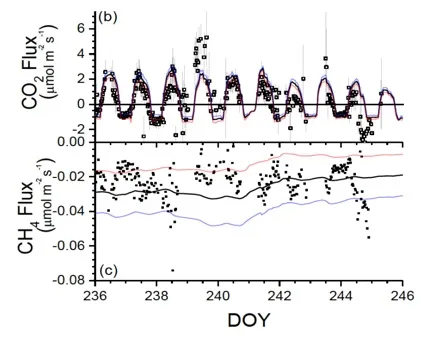
Ecosys accurately represented eddy covariance measured surface (b) CO2 and (c) CH4 emissions when scaled from individual polygons to the landscape.
Grant, RF, ZA Mekonnen, WJ Riley, HM Wainwright, D Graham, and MS Torn. 2017. Mathematical modelling of arctic polygonal tundra with ecosys: 1. Microtopography determines how active layer depths respond to changes in temperature and precipitation. Journal of Geophysical Research: Biogeosciences, 122:3161– 3173. https://doi.org/10.1002/2017JG004035
This research was supported by the Director, Office of Science, Office of Biological and Environmental Research of the US Department of Energy under Contract No. DE-AC02-05CH11231 as part of the Next-Generation Ecosystem Experiments (NGEE Arctic) project.
For more information, please contact:
William Riley
wjriley@lbl.gov