
Mapping Vegetation Communities using Convolutional Neural Networks
Date Published
Artificial intelligence applied to multiple remote sensing datasets accurately represents shrub distribution across hillslopes at the Kougarok field site.
Objective
- Develop a deep learning approach (convolutional neural network) capable of generating vegetation maps for the Seward Peninsula in western Alaska.
New Science
- Unique training dataset was collected at 30 field plots and the resulting vegetation products evaluated against them for accuracy.
- Fusion of hyperspectral, multispectral, and terrain datasets was performed over a 343 km2 region.
- High-resolution (5 m) vegetation classification map was generated.
Impact
- Produced one of the most accurate, high resolution, field-validated vegetation maps for tundra ecosystems.
- Using map now to benchmark field predictions of plant distribution and dynamics across changing Arctic landscapes.
Image with caption
Image
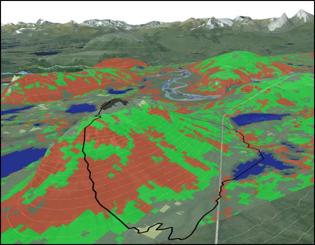
Vegetation community types (e.g., shrubs) mapped for the NGEE Arctic Kougarok watershed and the surrounding region using multi-sensor fusion of remote sensing data and topography with machine learning methods.
Citation(s)
Text
Langford, Z, J Kumar, F Hoffman, A Breen, and C Iversen. 2019. Arctic vegetation mapping using unsupervised training datasets and convolutional neural networks. Remote Sensing 11:69. https://doi.org/10.3390/rs11010069
Funding
This research was supported by the Director, Office of Science, Office of Biological and Environmental Research of the US Department of Energy under Contract No. DE-AC02-05CH11231 as part of the Next-Generation Ecosystem Experiments (NGEE Arctic) project.
For more information, please contact:
Zachary Langford
langfordzl@ornl.gov