Landscape Mapping using Remote Sensing and Neural Networks
Date Published
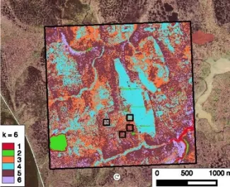
A convolutional neural network (CNN) approach produced highly accurate vegetation classifications. Hyper-spectral datasets (e.g., AVIRIS) were most useful for our machine learning approaches. Accurate and high-resolution datasets generated using our approach are needed for Arctic models.
Objective
- Develop high-resolution maps of Arctic vegetation using machine learning and satellite imagery (e.g., NASA).
New Science
- A convolutional neural network (CNN) approach produced highly accurate vegetation classifications. Hyper-spectral datasets (e.g., AVIRIS) were most useful for our machine learning approaches. Accurate and high-resolution datasets generated using our approach are needed for Arctic models.
Impact
- Remote sensing products were combined and maps of vegetation distribution evaluated against field data for the Seward Peninsula
Citation(s)
Funding
This research was supported by the Director, Office of Science, Office of Biological and Environmental Research of the US Department of Energy under Contract No. DE-AC02-05CH11231 as part of the Next-Generation Ecosystem Experiments (NGEE Arctic) project.
For more information, please contact:
Forrest Hoffman
hoffmanfm@ornl.gov

