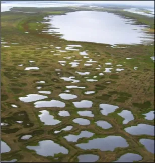
Analysis of Pond and Lake Quantifies Size-Class Distribution of Water Bodies in High-Latitude Ecosystems
Date Published
Objective
Quantify spatial heterogeneity of lakes and ponds provides a resource that can be used to benchmark land surface models.
New Science
- Small waterbodies (<10 ha) represent a large fraction of Arctic landscapes and regulate CO2 and CH4 fluxes.
- Application of size class distributions in land surface models (i.e., ALM) will improve projections of surface inundation and carbon fluxes in permafrost lowlands.
Impact
- Time-series analysis of data sets from 1948 to 2013 and from a variety of airborne and satellite imagery.
- High-resolution maps and classification scheme for lakes and ponds covering a wide range of landscapes from tundra to boreal regions and from continuous to discontinuous permafrost zones.
Funding
This research was supported by the Director, Office of Science, Office of Biological and Environmental Research of the US Department of Energy under Contract No. DE-AC02-05CH11231 as part of the Next-Generation Ecosystem Experiments (NGEE Arctic) project.


