
Strong feedback among soil, terrain, and vegetation properties and snow accumulation that create heterogeneity in thermal, hydrological, and biogeochemical regimes across the studied watershed.
Understanding the interactions among bedrock, permafrost, soil, terrain, vegetation, and atmospheric processes in the Arctic is critical for predicting the storage and flux of carbon and water in a changing climate. Quantifying above- and belowground interactions in the Arctic is challenging because of their spatial variability as well as process complexity and lack of sensing systems to jointly monitor key processes. To overcome these challenges, the team coupled various strategies, including (1) low-cost and low-power distributed temperature profiling systems for quantifying soil and snow temperature and related properties (e.g., snow thickness and soil thermal parameters) with unprecedented spatial and temporal density; (2) electrical resistivity tomography, in-well measurements, and soil samples to investigate spatially variable subsurface structure and hydrology; (3) mapping of ground elevation, vegetation height, and snow thickness using unoccupied aerial vehicles; (4) integration of the geophysical, point-scale, and remote sensing data to evaluate the controls on permafrost and thermal regimes distribution and to identify remote sensing indicators that can be used for scaling knowledge from site to larger scales; and (5) supporting data-driven understanding with a global sensitivity analysis applied on an ecosystem model (ecosys) to evaluate key processes that need to be included in models. The team applied these strategies in a watershed with discontinuous permafrost along Teller Road near Nome, Alaska to understand the permafrost distribution and evaluate the controls on soil thermal regimes and associated hydro-biogeochemical processes. The field data and model sensitivity analysis consistently show that thick snowpack and tall vegetation are collocated with warmest soil mean annual temperature, highlighting the importance of feedbacks among temperature, vegetation growth, and increased snow accumulation. Results also indicate the effects of soil thermal parameters and subsurface hydrology. However, disentangling the various subsurface mechanisms remains challenging. Additional investigation will strongly benefit from the recent installation of 15 wells across the watershed and in-well monitoring equipment.
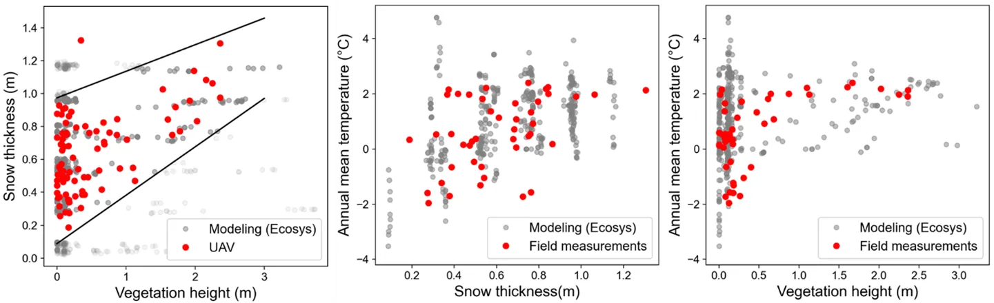
The relationships among vegetation height, snow thickness, and soil annual mean temperature at 0.5 m depth observed in the data and model runs. The middle and right panels include only model runs that match the observed relationship between vegetation height and snow thickness (i.e., models runs located between the two black lines in the left panel). These results highlight the feedback mechanisms among soil warming, plant growth, and snow accumulation. The point scattering in the middle and right panels indicates the role of additional controls, such as variation in soil thermal and hydrological properties that modulate heat fluxes, on soil temperature.
For more information, please contact:
Baptiste Dafflon
bdafflon@lbl.gov