
We conducted our first NGEE-Arctic deployment of the multi-instrument Osprey heavy-lift octocopter at the three Seward Peninsula sites where we collected high-resolution visible imagery for structure from motion (SfM) 3-D plant and terrain surface heights, thermal infrared imagery for surface temperature variation, and dual spectrometer, high spectral resolution, plant reflectance measurements to enable trait scaling. Following successful test flights, software development, and automated instrument collection prototype work at BNL, we deployed our heavy-lift Osprey octocopter Unmanned Aerial System (UAS) platform in the Seward Peninsula in support of NGEE-Arctic Q3 and Q4 goals. Our Osprey platform contains dual visible through near-infrared (VNIR) spectrometers covering the 400-1100nm spectral range to collect surface reflectance, a camera to collect very high spatial resolution imagery for Structure from Motion (SfM) 3-D surface rendering, and a calibrated thermal camera for measuring variation in surface and plant temperatures. During this deployment we used our recently-developed open-source software package, the Modular Data Collection System (MoDaCS), to automate instrument collection in conjunction with the UAS flight control computer. This software also provided real-time data streaming to our ground control station to monitor data collection, instrument health, and other key variables such as telemetry and battery voltage. Data from these UAS flights will help enable the scaling of plant traits (Q3) and the characterization of plant and landscape properties (Q4) needed to support the NGEE-Arctic modeling goals. We are currently developing data products for the NGEE portal and have begun work on preparing a manuscript.
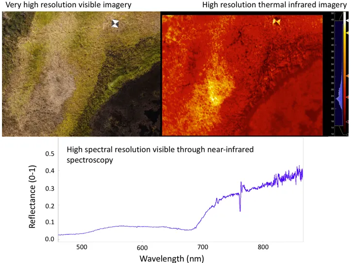
Example imagery and spectral data over a section of a thaw pond near Council, AK from the Osprey UAS platform. A very high spatial resolution image from the camera over the edge of the thaw pond (top left), and a paired thermal infrared image with temperature scale (top right)
For more information, please contact:
Shawn Serbin
sserbin@bnl.gov