
In a collaboration with Prof. Robert Grant of the University of Alberta, we applied ecosys to quantify and spatially scale the effects of fine-scale polygonal microtopography on thermal, hydrological, and biogeochemical dynamics at our BEO sites (Grant et al. 2017). Ecosys is a three-dimensional coupled biogeochemistry, hydrology, vegetation, and thermal model that has been applied and tested in many high-latitude sites. We first demonstrated excellent agreement between ecosys predictions and NGEE-Arctic observations of soil temperature and moisture, eddy covariance energy and CO2 fluxes, and chamber CH4 fluxes (see figure). We found that microtopographic variation among troughs, rims, and centers strongly affects movement of surface water and snow, and thereby affects soil water contents and active layer development. Spatial variation in active layer depth (ALD) caused by these features often exceeded interannual variation caused by changes in air temperature. Consistent with measurements, increases in near-surface soil moisture with decreasing surface elevation among polygon features increased thermal conductivity, soil heat fluxes, and hence ALD by up to 15 cm. The modeled interannual variation in ALD also compared well with measurements from 1985 to 2014 at the Barrow CALM site. For higher polygon features, interannual variation in ALD was more closely associated with annual precipitation than mean annual temperature, indicating that soil wetting from increases in precipitation may hasten permafrost degradation beyond that caused by increases in air temperature. We are pursuing this last idea in ongoing Alaska-wide ecosys simulations, and incorporating the required mechanisms in the DOE E3SM Land Model (ELM; see Highlight on Bisht et al. 2017) for pan-Arctic simulation.
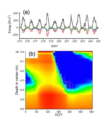
Ecosys accurately represented the BEO polygonal tundra site (a) eddy covariance measured surface energy and water fluxes and (b) soil thermal and ice content (shown for a Low-Centered Polygon center).
For more information, please contact:
William Riley
wjriley@lbl.govRobert Grant
rfgrant@ualberta.edu