
From under the clouds to in the clouds: unoccupied aerial systems and piloted sub-orbital airborne remote sensing enables scientists to better characterize the spatial variation in Arctic vegetation composition across scales.
Widespread changes in vegetation cover and composition are responsible for significant effects on Arctic ecosystem functioning and global climate feedbacks. However, accurately quantifying the composition and distribution of tundra vegetation over large areas is challenging given that commonly used satellite observations are too coarse to differentiate low-lying tundra vegetation types. To address this problem, the team combined very-high-resolution (VHR, ~5 cm) unoccupied aerial system (UAS) imagery and hyperspectral Airborne Visible/Infrared Imaging Spectrometer, Next Generation (AVIRIS-NG) airborne data to develop novel scaling methods to map the fractional composition of 12 key low-Arctic tundra plant functional types (PFTs). Therefore, the team first mapped the 12 PFTs using data from our UAS platform with a random forest classification approach. These UAS-derived PFT maps were then used as dense training data to develop partial least squares regression (PLSR) models to predict the continuous fractional cover (FCover) of each PFT with AVIRIS-NG imagery. We evaluated the performance of our PLSR models using UAS data reserved from model training, as well as by comparing our PFT FCover and dominant PFT maps with those from a fully constrained least-squares (FCLS) analysis at larger tundra landscapes. The team showed that (1) a wide-range of Arctic PFTs can be mapped using VHR UAS imagery, with an overall accuracy between 86% and 92%, (2) these maps can be used as training data for larger-scale models developed with AVIRIS-NG imagery, with a mean absolute error (MAE) <0.13, and (3) our PLSR models outperformed traditional linear mixture analysis. Our new models and scaling approach can likely be transferred to other areas in the Arctic and has the potential to more broadly characterize vegetation composition to aid in the monitoring of tundra vegetation dynamics and improve process-based modeling of tundra ecosystems.
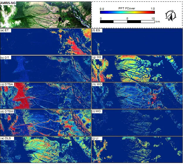
Example maps of PFT fractional cover for the Council, AK region for 10 PFTs (a) evergreen tree (ET), (b) deciduous tree (DT), (c) deciduous tall shrub – alder (DTSA), (d) deciduous tall shrub – willow (DTSW), (e) deciduous low shrub, (f) evergreen shrub (ES), (g) dry graminoid (DG), (h) wet graminoid (WG), (i) moss (MO), and (j) lichen (LI). Deciduous dwarf shrub (DDS) and forb (FO) are not displayed here, as they have minor FCover within this region.
For more information, please contact:
Daryl Yang
yangd@ornl.gov