
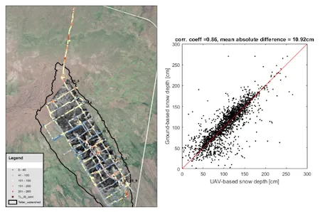
Snow is the main driver of the hydrologic cycle in Arctic and subarctic watersheds around the globe. NGEE Arctic researchers from LANL and LBNL set out to collect snow measurements to record important information about snow and snow processes in a watershed located on the Seward Peninsula near Nome, AK. The watershed is underlain by discontinuous permafrost, and researchers are actively working to understand the complex and dynamic interactions between snow, permafrost, and shrubs that are rapidly shifting in the face of Arctic climate change. LANL researchers have gone out since 2016 to collect ground-based measurements of the snow depth and snowpack properties using a snow corer along with a Magnaprobe and GPS. In 2018 and 2019, LBNL scientists collected spatially continuous measurements of snow surface elevation with an Unmanned Aerial Vehicle (UAV) and inferred snow depth by subtracting a digital terrain model from the snow surface elevation model. Early analysis and intercomparison of the 2019 datasets show that ground- and UAV-based measurements are consistent and that snow depths can be captured relatively accurately using a UAV. The lowest coherency between the ground- and UAV-based measurements is observed in regions with high spatial heterogeneity in ground and surface elevation, where the GPS accuracy (including from ground-based measurements) and the quality of the snow and terrain elevation models are limiting factors. Overall, the high quality of the datasets will enable critical improvements in understanding spatial distribution of snowpack properties and their link with vegetation, topographic and subsurface properties. As work progresses, the teams are collaborating closely to share details of the work with the peer reviewed research community. Findings will be used to inform a new Arctic snow redistribution model for the land model component (ELM) of DOE’s Energy Exascale Earth System Model (E3SM).
Empty
For more information, please contact:
Katrina Bennett
kbennett@lanl.govBaptiste Dafflon
bdafflon@lbl.gov