
Geomorphological and thermo-hydrological changes to tundra, caused by a wildfire in 2002 on the central Seward Peninsula, were investigated by Go Iwahana (UAF) and others as a case study for understanding the response from ice-rich permafrost terrain to surface disturbance. Frozen and unfrozen soil samples were collected at burned and unburned areas, and then water isotope geochemistry and cryostratigraphy of the active layer and near-surface permafrost were analyzed to investigate past hydrological and freeze/thaw conditions, and how this information could be recorded within the permafrost. Go explained that the development of thermokarst subsidence due to ice-wedge melting after the fire was clear from analyses of historical sub-meter-resolution remote sensing imagery, long-term monitoring of thermo-hydrological conditions within the active layer, in-situ surveys of micro-relief, and geochemical signals recorded in the near-surface permafrost. The resulting polygonal relief coincided with depression lines along an underground ice-wedge network, and cumulative subsidence to 2013 was estimated as at least 10.1 to 12.1 cm (0.9-1.1 cm/year eleven-year average). Profiles of water geochemistry in the ground indicated mixing or replenishment of older permafrost water with newer meteoric water, as a consequence of the increase in active layer thickness due to wildfire or past thaw event. This case study demonstrated the irreversible thermokarst process in disturbed tundra underlain by an ice-wedge network could lead at first to a wetter tundra, favorable for peat accumulation, and then later to drier surface conditions as a whole, which is more susceptible to the decomposition of surface organic matter. Additionally, distinct hydrogen and oxygen isotopic compositions above the Global Meteoric Water Line were found for water from these sites where permafrost degradation with geomorphological change and prolonged surface inundation were suggested.
Reference:
Iwahana G, M Uchida, L Liu, W Gong, FJ Meyer, R Curitz, T Yamanokuchi, and L Hinzman. 2016. InSAR detection and field evidence for thermokarst after a tundra wildfire, using ALOS-PALSAR. Remote Sensing 8: Article 218. http://dx.doi.org/10.3390/rs8030218
[[{"fid":"184","view_mode":"default","type":"media","link_text":null,"attributes":{"title":"Figure 1. Surface change before and after the 2002 wildfire. The right side of the area was burned in 2002, while the left side remained intact. a) Aerial photography taken on 3 August 1985; b) Google Earth satellite image from 8 July 2000; c) Google Ear","height":"747","width":"980","class":"media-element file-default"}}]]
Figure 1. Surface change before and after the 2002 wildfire. The right side of the area was burned in 2002, while the left side remained intact. a) Aerial photography taken on 3 August 1985; b) Google Earth satellite image from 8 July 2000; c) Google Earth satellite image from 26 August 2006; d) Satellite image from 23 September 2013 (true color, WorldView2, DigitalGlobe).
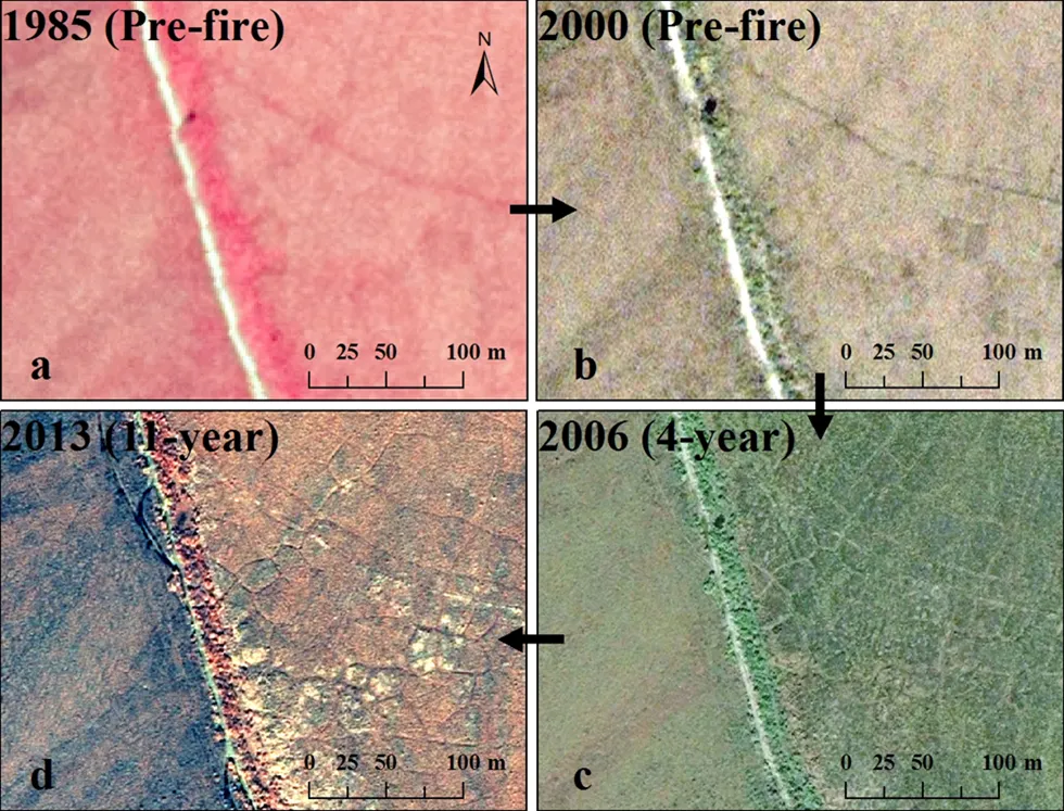
Figure 1. Surface change before and after the 2002 wildfire. The right side of the area was burned in 2002, while the left side remained intact. a) Aerial photography taken on 3 August 1985; b) Google Earth satellite image from 8 July 2000; c) Google Earth satellite image from 26 August 2006; d) Sa
For more information, please contact:
Go Iwahana
giwahana@alaska.edu