
Researchers used remote sensing and random forest models to quantify the importance of landscape parameters including topography, vegetation, and meteorological factors.
Root-zone soil moisture exerts a fundamental control on vegetation, energy balance, and the carbon cycle in Arctic ecosystems, but it is still not well understood in vast, remote, and understudied regions of discontinuous permafrost. The root-zone soil moisture product (30 m resolution) used in this analysis was retrieved from time-series P-band (420–440 MHz) synthetic aperture radar (SAR) backscatter observations collected in August and October 2017. Similar approaches have been taken to retrieve surface (i.e., 0 to 5 cm) soil moisture from an L-band (1.2 GHz) SAR backscatter, but this is one of the first known attempts to reach the root zone in permafrost regions. The team analyzed secondary factors (excluding primary factors such as precipitation) controlling soil moisture at depths of 6, 12, and 20 cm over a 4,500 km2 area on the Seward Peninsula of Alaska in August. Using a random forest model, the team quantified the effects of topography, vegetation, and meteorological factors on soil moisture distributions. In developing the random forest model, the team explored 30, 60, 90, 120, 180, and 240 m feature scales as well as tune hyperparameters (i.e., the individual structures, number, and depth of decision trees making up the ensemble) and performed the final feature selection using cross-validated recursive feature elimination. Results suggest that root-zone soil moisture on the Seward Peninsula is primarily controlled by vegetation at 6 cm; however, topography and meteorological factors such as predominant winter wind direction and summer insolation play larger roles deeper in the soil column. The random forest model accounts for 40% to 60% of the variation observed (R2 = 0.44 at 6 cm, 0.52 at 12 cm, and 0.58 at 20 cm). These results indicate that while vegetation is the dominant control on soil moisture shallow in the soil column, its influence diminishes in deeper layers retrieved from the P-band SAR backscatter.
Citation: Dann, J., K. E. Bennett, W. R. Bolton, and C. J. Wilson. 2022. “Factors controlling a synthetic aperture radar (SAR) derived root-zone moisture product over the Seward Peninsula of Alaska.” Remote Sensing 14: 4927. https://doi.org/10.3390/rs14194927.
Contact: Julian Dann, University of Alaska Fairbanks, jdann@alaska.edu
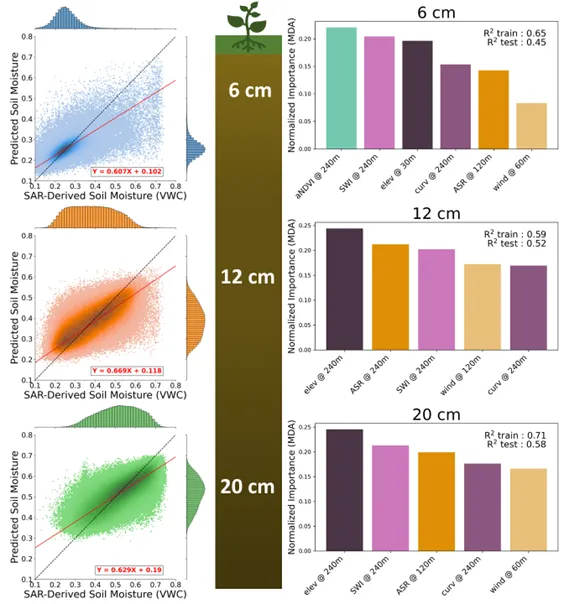
The relationships between SAR-derived soil moisture and random forest soil moisture predictions at 6, 12, and 20 cm. The dashed black line is the 1:1 and the solid red line is the result of a robust linear regression (Huber). The distribution for the SAR-derived soil moisture is shown along the top border of the plot, and the distribution for the predicted soil moisture is shown along the right border. The bar graphs on the right show indicators of feature importance (i.e., mean decrease in accuracy [MDA]) for input features for the final fits.