
Characterizing the primary environmental controls on watershed soil water geochemical variation in the Arctic is critical to better understand geochemical cycling and predict future changes.
We quantified biogeochemical cycling across two contrasting hillslope sites on the Seward Peninsula, Alaska to address knowledge gaps in our understanding of biogeochemical cycles in a changing arctic. We sampled soil pore water (SPW) from the upper 30 cm of soil using fiberglass wicks and MacroRhizons and paired these data with additional observations of vegetation characteristics, soil moisture, and permafrost extent to understand the dominant environmental controls over solute concentrations in SPW. Vegetation had a significant impact on SPW nitrate concentrations—associated with the localized presence of nitrogen-fixing alders—and mineralization and nitrification of leaf litter from tall willow shrubs. Furthermore, topographic differences and a lack of well-defined drainage channels were found to be the likely environmental controls resulting in systematically higher SPW solute concentrations at one study site. Overall, this study suggests that evaporative concentration could be a significant control on SPW solute concentrations in permafrost catchments, especially in those with a perched near-surface water table.
Citation: Conroy NA, Heikoop JM, Lathrop E, Musa D, Newman BD, Xu C, McCaully RE, Arendt CA, Salmon VG, Breen A, Romanovsky V, Bennett KE, Wilson CJ, Wullschleger SD. 2023. Environmental controls on observed spatial variability of soil pore water geochemistry in small headwater catchments underlain with permafrost. The Cryosphere 17: 3987–4006. https://doi.org/10.5194/tc-17-3987-2023.
Associated Dataset: Conroy N, Heikoop J, Newman, B, Wilson C, Arendt C, Perkins G, Wullschleger S. 2021. Soil water chemistry and water and nitrogen isotopes, Teller Road site and Kougarok Hillslope, Seward Peninsula, Alaska, 2016–2019. Next Generation Ecosystem Experiments (NGEE) Arctic, ESS-DIVE repository. Dataset accessed via https://data.ess-dive.lbl.gov/datasets/doi:10.5440/1735757.
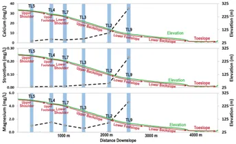
Median (50th percentile) concentrations (gray diamonds with dashed black lines) of calcium, strontium, and magnesium, with distance downslope at the Teller study site along topographic transects; areas of intensive stations are indicated by blue coloring. The elevation profiles of the hillslopes are plotted in green on separate y-axes (right axes). Topographic regions are indicated by red arrows along the elevation gradient.
For more information, please contact:
Nathan Conroy