
The Unmanned Aerial System (UAS) LiDAR team from Los Alamos National Laboratory surveyed the entire NGEE-Arctic Teller research site (~3km2) in August 2017. The UAS carries a state-of-the-art Light detection and Ranging (LiDAR) scanner that acquires centimeter-resolution topography data in the form of a point-cloud (Figure 1). In addition to LiDAR, the UAS is equipped with a digital camera that collects high-resolution aerial imagery at 24 Megapixels. We installed and surveyed 65 ground control points distributed across the watershed to improve geographic accuracy of the LiDAR and photogrammetry products. The capacity of UAS LiDAR to acquire very-fine observations of the geosphere and ecosphere has revolutionized the earth sciences and our ability to answer foundational and interdisciplinary questions of environmental processes. The Digital Elevation Model from the LiDAR point-cloud acquired at the Teller site will serve as a keystone dataset to better understand the association and co-dependence between topography and multiple environmental processes related to hydrology, geochemistry, geomorphology as well as the relationship between ecosystem structure and function. In addition, this dataset will be used to parameterize the mesh of process-based regional models being developed by NGEE-Arctic.
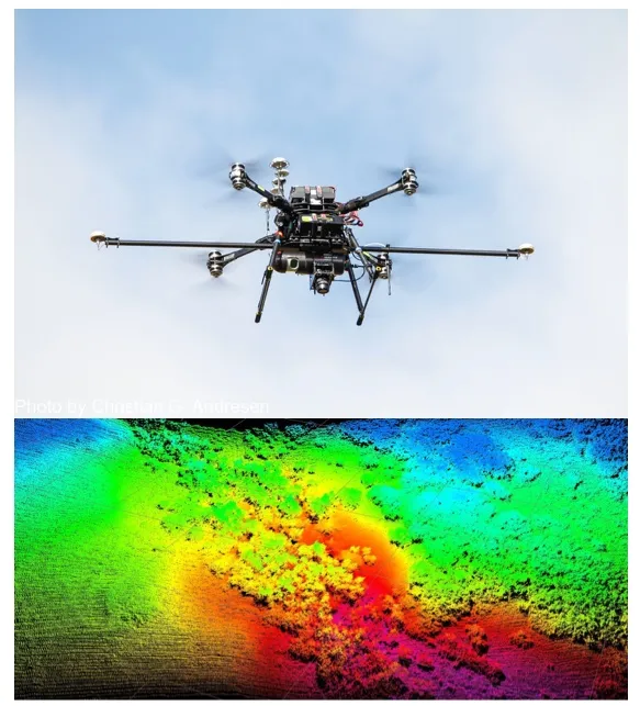
(Top) UAS flying over the study site with a LiDAR scanner and 24MP Camera as payloads. (Bottom) A snapshot of the raw LiDAR point cloud data collected at the study site. Color gradient represents elevation.
For more information, please contact:
Christian Andresen