
The presence and thawing of permafrost strongly control both gradual and catastrophic movements of soil on watershed hillslopes in complex and often difficult to predict patterns and rates.
Thawing permafrost can alter topography, ecosystems, and sediment and carbon fluxes, but predicting landscape evolution of permafrost-influenced watersheds in response to warming and/or hydrological changes remains an unsolved problem. Sediment flux and slope instability in sloping saturated soils have been commonly predicted using topographic metrics (e.g., slope, drainage area). In addition to topographic factors, cohesion imparted by soil and vegetation and melting ground ice may also control spatial trends in slope stability, but the distribution of ground ice is poorly constrained and difficult to predict. To address whether slope stability and surface displacements follow topographic-based predictions, the team documented recent drivers of permafrost sediment flux present on a landscape in western Alaska. These drivers include creep, solifluction, gullying, and catastrophic hillslope failures ranging in size from a few meters to tens of meters, and the team found evidence for rapid and substantial landscape change on an annual timescale. The timing and rate of surface movements were quantified using a multi-pronged, multi-scalar dataset including aerial surveys, interannual GPS surveys, interferometric synthetic aperture radar (InSAR), and climate data. Annual displacements do not appear related to slope, drainage area, or solar radiation but are likely related to soil thickness, and volumetric sediment fluxes are high compared to those of similar temperate landscapes. Timeseries of InSAR displacements show accelerated movement in late summer, associated with intense rainfall and/or deep thaw. Although mapped slope failures do cluster at slope–area thresholds, a simple slope stability model driven with hydraulic conductivities representative of throughflow in mineral and organic soil drastically over-predicts the occurrence of slope failures. The team’s results highlight the breadth and complexity of soil transport processes in Arctic landscapes and demonstrate the utility of using a range of synergistic data collection methods to observe multiple scales of landscape change, which can aid in predicting periglacial landscape evolution.
Citation: Del Vecchio, J., E. Lathrop, J. B. Dann, C. G. Andresen, A. D. Collins, M. M. Fratkin, S. Zwieback, R. C. Glade, and J. C. Rowland. 2023. “Patterns and rates of soil movement and shallow failures across several small watersheds on the Seward Peninsula, Alaska.” Earth Surface Dynamics. https://doi.org/10.5194/esurf-2022-43.
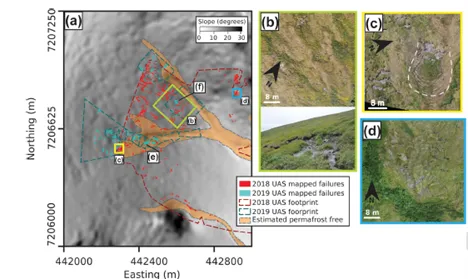
Landforms and slope failures at the Teller 47 watershed. (a) Slopeshade of ArcticDEM topography model overlaid with mapped failures in 2018 (red) and 2019 (cyan). (b) Many small arcuate failures occur on the steeper slopes of the watershed. (c) The area around the two channels exhibited detachment of the tundra mat from the underlying mineral soil in arcuate shapes (white dashed line). Separation of the tundra at the head of a failure results in rumpled tundra at the toe. (d) In an area of more convergent topography, overland flow incised through the tundra mat and exposed mineral soil
For more information, please contact:
Joanmarie Del Vecchio
Joel Rowland
jrowland@lanl.gov